Data production and validation methodology
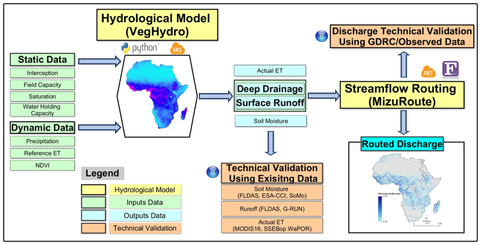
Figure 1. Integrated workflow of the VegET (Senay et al., 2023) and mizuRoute (Mizukami et al., 2016) modeling frameworks
The discharge data presented on the dashboard, known as AfriDischarge v1 (also called VegDischarge v1), provides comprehensive coverage of over 64,000 river segments across Africa. The dataset spans from 2001 to 2021 and was generated through an integrated modeling approach combining two key models as explained in Figure 1.
This schematic outlines the key processes involved in implementing the VegET hydrological model (developed in Python) and the mizuRoute river routing model (developed in Fortran). It illustrates the inputs—categorized as static parameters (e.g., soil and interception characteristics) and dynamic parameters (e.g., climate data and vegetation phenology)—as well as the resulting outputs, including surface runoff, deep drainage, soil moisture, and river discharge estimates.
In this integrated framework, VegET simulates the components of the root zone water balance (actual evapotranspiration, soil moisture, runoff) at a high spatial resolution of 1 km, using remote sensing inputs like CHIRPS, ERA5, MSWEP precipitation, and MODIS-derived NDVI for vegetation dynamics. The model accounts for land surface phenology and differentiates between surface runoff and subsurface drainage using a runoff partitioning scheme. Read more
VegET hydrological model
The VegET model is a physically based, bucket-type hydrological model that simulates key water balance components such as evapotranspiration, soil moisture, surface runoff, and deep drainage at a spatial resolution of 1 km. The model is primarily driven by remote sensing data, including precipitation and Normalized Difference Vegetation Index (NDVI), which facilitates capturing the diverse hydrological processes across Africa (Figure 2). Precipitation data sources such as CHIRPS, ERA5, and MSWEP, alongside soil property data from ISRIC and vegetation data from MODIS, ensure robust and accurate simulation outcomes. Read more
Routing methodology
The gridded runoff output from VegET is subsequently routed using the mizuRoute model, a vector-based river network routing tool (Figure 1). mizuRoute utilizes Hydrological Response Units (HRUs) sourced from the Hydrologic Derivatives for Modeling and Analysis (HDMA) database. To enhance the accuracy of discharge estimation, particularly in complex hydrological environments like tropical rainforests, deep drainage and surface runoff partitioning were applied using region-specific coefficients (Figure 2). This process involves a bias correction factor (β), which adjusts for underestimations observed in regions such as the Congo River Basin.
Technical validation
The performance and reliability of VegDischarge v1 were rigorously validated against observational data from the Global Runoff Data Centre (GRDC). Validation was performed at annual and monthly time scales, covering numerous stations across Africa, to ensure robust results (Figures 3, 4). At the continental scale, the model demonstrated strong performance with high correlation (R² = 0.5–0.9), Nash-Sutcliffe efficiency (NSE = 0.6–0.9), and Kling-Gupta Efficiency (KGE = 0.5–0.8), indicating its capability to accurately replicate observed hydrological patterns across diverse climatic and hydrological conditions. Read more
Publications
- Akpoti, K., Velpuri, N.M., Mizukami, N. et al. Advancing water security in Africa with new high-resolution discharge data. Sci Data 11, 1195 (2024). https://doi.org/10.1038/s41597-024-04034-0
- Akpoti, K., Mekonnen, K., Leh, M., Owusu, A., Dembélé, M., Tinonetsana, P., Seid, A., Velpuri, N. M. (2024). State of continental discharge estimation and modelling: challenges and opportunities for Africa. Hydrological Sciences Journal, 69(15), 2124–2152. https://doi.org/10.1080/02626667.2024.2402938
- Akpoti, K., Velpuri, N.M., Mizukami, N., Kagone, S., Leh, M., Mekonnen, K., Owusu, A., Tinonetsana, P., Phiri, M., Madushanka, L., Perera, L., Prabhath, P.T., Parrish, G.E.L., Senay, G.B., and Seid, A., 2024, Hydrologic gridded runoff and routed discharge data for Africa from 2000-2021: U.S. Geological Survey data release, https://doi.org/10.5066/P14H6TFY.
- The continent’s ability to adapt to climate change depends, in part, on accurate river discharge estimation. https://www.iwmi.org/blogs/iwmi-research-offers-a-path-to-better-river-discharge-estimation-in-africa/